← Model comparison

Claude Fable 5

This is the final report readers received. Expand the yellow notes to see wording or claims changed after the independent fact-check.

World aviation watch - 2026-07-15 1442Z

About 15,100 aircraft in the feed at the anchor (2-minute collapse); the visible picture is mostly Western. Today: an emergency descent over Utah, a four-flag firefight over Cyprus, a spoofer painting circles near Smolensk, and day two on the Hormuz tanker anchors.

An emergency descent over Utah, live

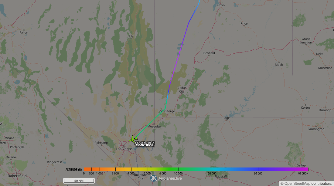
SKW3681, a SkyWest E175 off Salt Lake City at 1406Z, leveled at FL360 - then came down hard from 1436Z at up to 8,000 ft/min, squawking 7700 from 1441Z: 22,000 ft shed in about seven minutes before leveling at 13,700 ft near St. George - the textbook shape of a pressurization-type emergency descent, though the cause is not in the data. After a dozen minutes level it diverted into Las Vegas, on the ground by 1512Z.

Aircraft tracking map accompanying “An emergency descent over Utah, live”
Changed after fact-check
  • The level segment near 13,700 feet was shortened from 20 minutes to about a dozen minutes, and the final version records that the aircraft had landed at Las Vegas.

Something near Smolensk is teleporting airliners

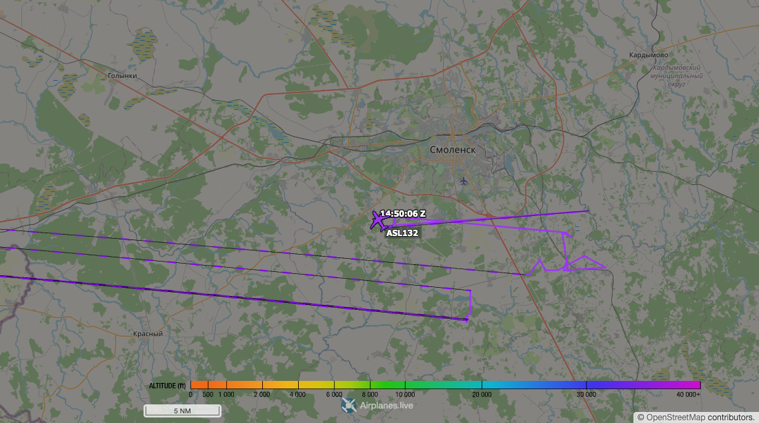
Three airliners - a Turkish flight, a Belavia 737, and Air Serbia’s ASL132 - were each plotted in a 1.2-nm circle at 52-56 kt around one point 10 km southwest of Smolensk, at cruise altitude. No jet flies like that. While ASL132’s transponder “orbited” Smolensk 1426-1451Z, multilateration put the real aircraft 400 km away over Lithuania. One fixed point, three aircraft, hours apart: spoofing from a shared external source, not an avionics fault.

Aircraft tracking map accompanying “Something near Smolensk is teleporting airliners”
Changed after fact-check
  • The explanation was softened from a ground-based spoofer to spoofing from a shared external source; the common false-position pattern itself was confirmed.

Turkey's drone fire-watch, all five towers manned

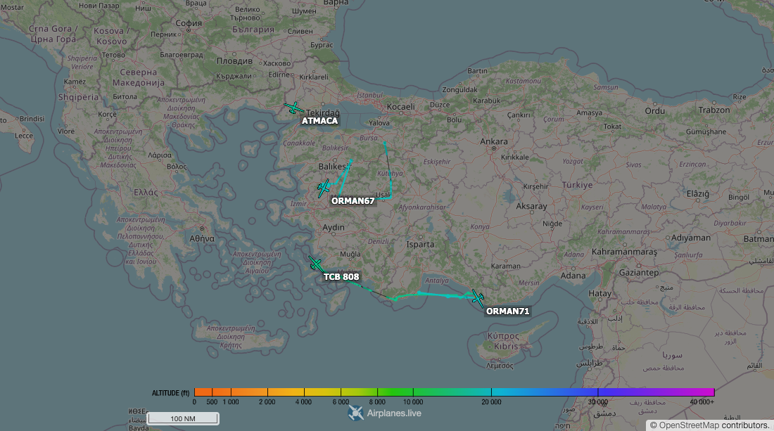
Six UAVs with forestry callsigns worked Turkey’s fire belt: ORMAN67, ORMAN71, ATMACA, and TCB 808 on station at the anchor, ORMAN69 and ORMAN73 earlier. Textbook fire watch: fixed 2-3 nm orbits, mostly 15,000-18,000 ft, one over each patch: Thrace, the Manisa belt, the Antalya coast, Bodrum, Adana. ORMAN67 logged nearly nine hours across three stations. Bases and orbits match, one for one, the five centers Baykar says the forestry directorate flies its fire-watch TB2s from.
Aircraft tracking map accompanying “Turkey's drone fire-watch, all five towers manned”
Changed after fact-check
  • Exact UAV start times and an across-the-board altitude and speed range were removed. The final says the six aircraft flew mostly in the stated band, allowing for transit, climb and descent samples outside it.
Day two on the Hormuz tanker anchors

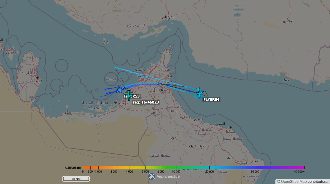
Yesterday’s two refueling anchors bracketing the Strait of Hormuz were staffed again: the Gulf of Oman anchor from before 0510Z onward by a relay of KC-46s - five airframes with overlapping handovers, the day’s last relief arriving as the picture closed - the Al Dhafra anchor by a KC-135R and a KC-46. Positions are MLAT and gappy - windows are minimums, and the overnight in between is unobserved. Same boxes, second day running.

Aircraft tracking map accompanying “Day two on the Hormuz tanker anchors”
Changed after fact-check
  • The Gulf of Oman relay was corrected from four KC-46 airframes to five. “Continuously” and “two days straight” were replaced with explicit MLAT gaps and an unobserved overnight period.

Two-way traffic on the eastern Med corridor

Airlift ran both ways across the eastern Med - US C-17 RCH347, Navy C-130 CNV5315 out of Sigonella, Qatari C-17 LHOB240, and German A400M GAF153 inbound at the anchor; Kuwaiti and Italian C-130Js and a NATO tanker rotated out. Odd leg: German C-130J GAF333 left Amman, flew a low out-and-back into the eastern Jordanian desert - an observed 5,750 ft, roughly 3,500 ft above the desert, with a gap at the far end - then landed at Tel Aviv.

Changed after fact-check
  • Incorrect aircraft coordinates were removed. The German C-130J’s low point is now stated as an observed 5,750 feet MSL, with the roughly 3,500-foot terrain clearance kept separate from the direct ADS-B observation.

Russian heavy metal around the Gulf

Two Russian Il-76s worked the Emirates: RA-76373, a Gelix Airlines airframe that shuttles Moscow-UAE, departed Sharjah 1355Z eastbound over the Gulf of Oman; RA-76370, an Abakan Air jet that has lived at Al Ain lately, flying overnight runs southeast beyond coverage, lifted off again at 1437Z. Abakan Air has been reported US-sanctioned since 2024 for military cargo flights (The Insider, defenceWeb). And RA-85042, one of the last flying Tu-154s, left Chkalovsky air base around 1353Z into the Gulf of Finland corridor, consistent with the Kaliningrad run.

Changed after fact-check
  • A stale last-seen detail was removed, and the Tu-154 departure was shifted from 13:51Z to about 13:53Z with a less precise route description.

The Cape's quiet company, day two

An unidentified US military aircraft - no callsign, no ADS-B positions, tracked only by multilateration - flew three north-south racetrack laps at 15,300 ft, 35 km off Cape Canaveral, 1343-1412Z, then broke off northeast. Same profile, same box yesterday, working out of the Jacksonville area. No space-ops TFR active; it worked the box alone.

Changed after fact-check
  • “MLAT-only” was changed to the more exact statement that the aircraft had no ADS-B positions and was tracked by multilateration; stale Mode-S reports did not provide independent positions.

Coming up, per the paperwork

Vandenberg airspace is reserved 2015-2100Z Friday for “SX SDA-T1TL-E” - reading as SpaceX launching Space Development Agency Tranche 1 Transport Layer satellites. Tonight 1700-0230Z New York Oceanic again closes a box to IFR traffic (USHER/IBEX), successor to last night’s MANGY boxes. And a Navy GPS-interference NOTAM runs daily windows over Lake Huron through July 24 - GPS, WAAS, and ADS-B may not be available within up to 228 nm of Alpena, widest at the highest altitudes.

ADS-B positions are coverage-limited and can be stale; non-US ownership is not available in this feed.

Changed after fact-check
  • A non-overlapping KELLY THREE reservation was no longer linked to the Vandenberg launch window. “GPS denial” became an altitude-dependent GPS-interference advisory because the notice says the services may be unavailable.